
File:ISS012-E-23598 NASA-Savai'i east end, Apolima strait, Upolu.jpg

Size of this preview: 800 × 531 pixels. Other resolutions: 320 × 212 pixels | 640 × 424 pixels | 1,024 × 679 pixels | 1,280 × 849 pixels | 3,040 × 2,016 pixels.
Original file (3,040 × 2,016 pixels, file size: 1.81 MB, MIME type: image/jpeg)
'Oto'otoga
| Description |
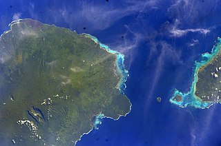
English: East side of Savai'i Island, Apolima, Manono & west end of Upolu |
| Date | |
| Source | Image Science and Analysis Laboratory, NASA-Johnson Space Center. "The Gateway to Astronaut Photography of Earth." <http://eol.jsc.nasa.gov/scripts/sseop/QuickView.pl?directory=ESC&ID=ISS012-E-23598> |
| Author | NASA |
| Camera location | | View this and other nearby images on: OpenStreetMap |
|---|
This image or video was catalogued by Johnson Space Center of the United States National Aeronautics and Space Administration (NASA) under Photo ID: ISS012-E-23598. This tag does not indicate the copyright status of the attached work. A normal copyright tag is still required. See Commons:Licensing. Other languages:
|
Licensing
This file is in the public domain in the United States because it was created by the Image Science & Analysis Laboratory, of the NASA Johnson Space Center. NASA copyright policy states that "NASA material is not protected by copyright unless noted". (NASA media use guidelines or Conditions of Use of Astronaut Photographs).
Photo source: ISS012-E-23598.
|
File history
Click on a date/time to view the file as it appeared at that time.
| Date/Time | Thumbnail | Dimensions | User | Comment | |
|---|---|---|---|---|---|
| current | 13:41, 18 Me 2013 | | 3,040 × 2,016 (1.81 MB) | Ras67 | new rendered from NASA's raw image data |
| 03:14, 7 Aokuso 2012 |  | 639 × 423 (88 KB) | Ras67 | rotated and cropped from NASA's original | |
| 13:43, 30 Ianuari 2010 |  | 639 × 435 (62 KB) | Teinesavaii | {{Information |Description={{en|1=East side of Savai'i Island, Apolima, Manono & west end of Upolu}} |Source=Image Science and Analysis Laboratory, NASA-Johnson Space Center. "The Gateway to Astronaut Photography of Earth." <http://eol.jsc.nasa.gov/scri |
File usage
The following page uses this file:
Global file usage
The following other wikis use this file:
- Usage on bn.wikipedia.org
- Usage on ceb.wikipedia.org
- Usage on de.wikipedia.org
- Usage on en.wikipedia.org
- Usage on es.wikipedia.org
- Usage on eu.wikipedia.org
- Usage on id.wikipedia.org
- Usage on ka.wikipedia.org
- Usage on mk.wikipedia.org
- Usage on mrj.wikipedia.org
- Usage on no.wikipedia.org
- Usage on pl.wikipedia.org
- Usage on ru.wikipedia.org
- Usage on sk.wikipedia.org
- Usage on uk.wikipedia.org
- Usage on ur.wikipedia.org
- Usage on www.wikidata.org
- Usage on zh.wikipedia.org